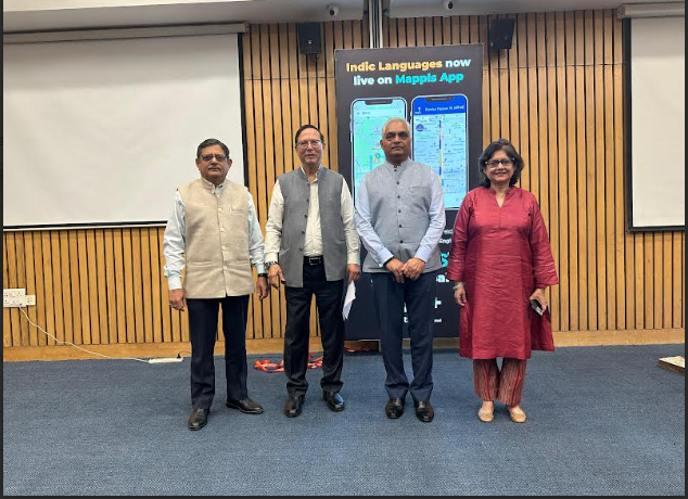
Press Release, 20 February 2025
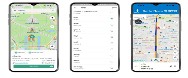
Mappls MapmyIndia has launched maps & navigation support for 9 regional languages on its Mappls App, accessible to it’s 30mn+ app users. The feature was launched by Surveyor General of India, Shri Hitesh Kumar S. Makwana, IAS at an event held at India International Center, New Delhi. This initiative reinforces Mappls’ commitment to inclusivity, making map and navigation seamless and accessible to all Indians, in their native languages and the company expects to further increase its user base with a slew of such India-centric features.
Users can have a fully native language experience with maps, search, turn-by-turn navigation and voice guidance in 9 Indian languages—Hindi, Tamil, Telugu, Bengali, Marathi, Kannada, Punjabi, Malayalam, and Gujarati – across the entire country. All 9 languages are available for the entire country and not just for the state/region, meaning a user in one state can read the map in their native language, travel to another state and continue to interact with the map in their native language.
This feature is one amongst a series of India-first features that have contributed to the app gaining 30m+ users in a short period. Other popular features that users rely on include Junction Views (for better, safer guidance, particularly around flyovers in 3D mode), traffic monitoring alerts, speed breakers, trip cost estimates, Mappls Pin and many more.
Speaking at the launch, Shri Hitesh Kumar S. Makwana, IAS, Surveyor General of India stated “I commend MapmyIndia for taking up this great initiative which is a strong example of ease of use of geospatial for the common man for their everyday needs. This also serves as the national digital infrastructure for location-based technology.”
Further, Mr. Rakesh Verma, Co-Founder & CMD, MapmyIndia, added, “India’s rich linguistic diversity is a strength, and at MapmyIndia, we believe in empowering every Indian with technology that speaks their language. With a fully native Indic-language experience in our Swadeshi Mappls App, we are taking a giant leap toward making navigation more inclusive. This initiative aligns with our vision of ‘Atmanirbhar Sarvottam Bharat’ and ‘Make in India, for India, and for the World.’
“With over 700 million smartphones in India, accessing navigation in their native language is essential. The Mappls App will feel as familiar as a local newspaper, ensuring seamless understanding and accessibility.”
This launch also marks a first for iOS users in India, as Mappls App becomes the only navigation platform to offer maps, search & turn-by-turn guidance in 9 Indic languages—a feature unavailable on other map apps.
Key Features of the Initiative:
● Multi-Language Support: Easily switch between Hindi, Bengali, Gujarati, Kannada, Malayalam, Tamil, Punjabi, English, Telugu, and Marathi for a personalized experience anywhere in the country.
● Voice Navigation: Get turn-by-turn voice guidance in all supported languages, ensuring safe, hands-free navigation in your favourite language.
● Localized Search: Find addresses, points of interest, and businesses in your preferred language, enhancing search convenience and accuracy.
The Mappls App is built on MapmyIndia’s industry-leading digital maps, covering:
● 99.9% of India’s road network encompassing 6.6 million kms
● 30 million+ businesses
● 550 million geo-referenced images
● 7,900+ towns and 637,000+ villages covered
Beyond traditional 2D maps, MapmyIndia is innovating with 3D landmarks, terrain models, 4D real-time updates, HD high-accuracy maps, and RealView 360-degree geo-tagged panoramas, continually enhancing its AI-powered Digital Metaverse Twin of the Real World.
With this launch, MapmyIndia reaffirms its leadership in digital mapping and navigation by prioritizing India’s diverse linguistic landscape. By integrating technology with cultural and linguistic inclusivity, Mappls App ensures that every Indian, regardless of their native tongue, can navigate the country with ease and confidence.
About MapmyIndia & Mappls (C.E. Info Systems Ltd) www.mapmyindia.com & www.mappls.com
C.E. Info Systems Ltd (NSE: MAPMYINDIA; BSE: 543425) is India’s leading advanced digital maps and deep-tech company, popularly known in India as MapmyIndia and globally as Mappls. The company offers proprietary digital maps as a service (“MaaS”), software as a service (“SaaS”) and platform as a service (“PaaS”), including its advanced digital map data, software products, platforms, application programming interfaces (“APIs”), IoT and solutions to new-age tech companies, large businesses, automotive OEMs, government organisations, developers and consumers. The company has served more than 2000 enterprise customers since its inception. The company pioneered digital mapping in India in 1995 and has earned its market leadership position in this industry and built a strong moat by capitalizing on our early mover advantage, developing proprietary and integrated technologies, full-stack product offerings, continuous innovation and robust sustainable business model. The company also built India’s very first internet mapping platform and portal, MapmyIndia.com (now called Mappls.com) in 2004. The company’s free Mappls app for consumers provides the best and fully indigenous maps, navigation, safety, hyper-local and IoT gadget-enabled experience for Indian users.
MapmyIndia has built India’s most comprehensive, accurate, feature-rich and continuously updated digital map data product down to address and urban building level detail pan India, covering all towns, villages, and the entire road network of the country. The company is building not just 2D maps, but also 3D (with landmarks, terrains and city models), 4D (updating in near real-time), HD (high-definition and high-accuracy), RealView (geo-tagged 360-degree panoramas, videos and photos representing actual ground reality), and hyper-local geo-demographics data-rich maps, to continuously evolve its AI-powered Digital Metaverse Twin of the Real World. The company is also building digital maps for other regions in the world and has integrated global maps for over 200 countries into its Mappls platform. The company’s platform provides extensive and comprehensive functionalities and an ever-expanding set of use cases, including mapping, location and navigation, geospatial data analytics, GIS (geospatial information systems) and AI, GPS tracking and IoT-based fleet management, logistics optimisation and workforce management, drone-based solutions, developer APIs, N-CASE solution suite (for Navigation, Connected vehicle telematics and services, ADAS safety i.e. advanced driving assistance systems, Shared and Electric) for Automotive & Mobility Tech (A&M), and Consumer tech and Enterprise digital transformation solution suite (C&E).