Augmenting GNSS technologies for V2X and automated driving

The best single-band GNSS receivers need ideal open-sky conditions to fulfil the accuracy requirements for V2X and automated driving. However, performance is lacking in urban and other challenging environments. A multi-band, RTK, dead-reckoning system using GNSS correction services and a dynamic vehicle model can overcome such limitations to reliably serve these use cases everywhere, all the time.
As the only technology capable of determining a car’s absolute position in real time, satellite-based positioning is essential for vehicle-to-vehicle and vehicle-to-infrastructure (V2X) applications, Advanced Driver-Assistance Systems (ADAS), and automated driving. Being independent of maps and landmarks, and using operating principles unrelated to sensing technologies such as cameras, LIDAR, ultrasound, and others, it provides a platform and backbone for the multi-sensor networks needed to enable higher levels of driving automation including full self-driving vehicles.
Historically, the limitations of Global Navigation Satellite System (GNSS) receiver technology have tended to restrict navigation-system performance, particularly in challenging scenarios such as urban canyons and multi-level road structures. Today’s receivers, however, are accurate to within just a few tens of centimeters and can achieve convergence time — the time to reach a specified accuracy level after the signal is interrupted and reacquired — of a just a few seconds. The typical latency — the delay between making the position measurement and reporting the position to the network — is approximately 10 milliseconds. Position updates can be delivered at well above 10Hz, and other technological enhancements have greatly improved positioning performance in urban environments.
In addition to improvements in GNSS receiver performance, semiconductor integration and Moore’s Law scaling has condensed the main system circuitry into a miniature, low-power chip that is suitable for use in portable, mass-market devices. Moreover, GNSS correction services made possible by ubiquitous wireless Internet connectivity minimize the influence on GNSS accuracy of errors due to ionospheric effects. Finally, multiple navigation constellations are now in place, including GLONASS, Beidou, and Galileo, in addition to GPS, which makes additional satellites visible to each receiver and ultimately enables a superior user experience.
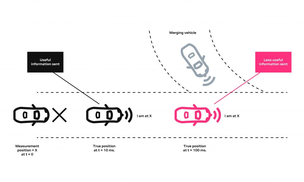
The combined effects of these improvements enable road vehicles equipped with the latest generation of multi-band, multi-constellation GNSS receivers to rely on positional accuracy within one meter and even down to a few tens of centimeters for some applications. In addition to high positioning accuracy, low latency is also a pre-requisite for applications such as automated driving and V2X, which describes vehicles exchanging wireless messages with each other and with roadside infrastructure to share warnings, receive information, and negotiate priority at intersections or when merging or overtaking. In these situations, long latencies in positioning data can cause erratic braking or acceleration, leading to poor passenger comfort or lowering the efficiency of truck platoons. At worst, unacceptable latencies can cause collisions that may be serious or even fatal, for example at highway speeds where vehicles travel the length of a car in a tenth of a second. The ETSI (European Telecommunications Standards Institute) standard for V2X communication requires system-level latency of less than 100 milliseconds for most use cases.

| Application | Accuracy | Environment | RTK required | Multi-band required | Latency |
| V2X | <1m CEP50 | Urban | No | yes | ~10ms |
| ADAS levels 1-3 | <20cm CEP50 | Urban | Yes | yes | ~10ms |
| ADAS levels 3-5 | <20cm CEP50 + Protection level | Urban | Yes | yes | ~10ms |
Note: All Applications require dead reckoning technology including wheel tick information. The CEP50 (circular error probability) value corresponds to the radius of the smallest circle that circumscribes 50 percent of all position measurements.
Sensor fusion for fast convergence
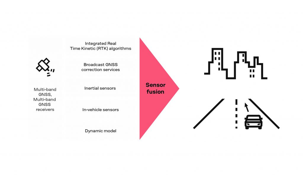
Robust and continuous lane-accurate positioning, even in challenging environments, is a key requirement if forthcoming V2X communication and automated driving are to become acceptable in the marketplace and mandated by authorities seeking to improve road safety and manage environmental effects such as traffic congestion and avoidable vehicle emissions. When satellite signals are temporarily obstructed, they need to recover the high precision position solution in seconds. This can be achieved by combining various complementary elements in a single sensor-fusion filter as shown in figure 2.

Multi-constellation, multi-band GNSS receivers:
With multiple GNSS constellations available, the inherent differences between the time differences of each constellation require receivers to “see” more satellites to unambiguously determine their position. When working with three constellations, roughly seven satellites are needed to compute the time differences whereas only four are needed to determine the position when using a single constellation. However, the greater number of satellites available more than compensates for this.
Additional unique capabilities of multi-band GNSS receivers include combining signals at different frequencies to eliminate specific errors. Techniques include simultaneously processing two signals from different frequencies to remove up to 99.9 percent of ionospheric error, and geometry-free combination for detecting cycle slips in the carrier phase.
Integrated Real Time Kinetic (RTK) algorithms:
Standard-precision GNSS receivers trilaterate their position by tracking the code phase of GNSS signals from at least four GNSS satellites. High-precision receivers, on the other hand, track the high-frequency carrier phase and typically use Real Time Kinematic (RTK) algorithms to resolve carrier-phase ambiguities. These can be integrated in the GNSS receiver module and utilize correction data delivered over a wireless connection. In the automotive market this is typically cellular and satellite L-band based communications. L-band receivers not only benefit from lower data transmission costs but also can receive RTK correction in locations where cellular connections are poor or unavailable, such as in rural areas.
Broadcast GNSS correction services:
By monitoring GNSS signals from a network of base stations, GNSS correction service providers can estimate signal errors continuously. One example is Precise Point Positioning (PPP)-RTK services, which compensate for satellite clock, orbit, signal bias, global ionosphere, and regional ionosphere and tropospheric effects. Ideally, corrections should be valid over large regions such as the continental United States and have minimal bandwidth requirements. Historically, these services have tended to send a tailored correction stream to individual users based on a rough position estimate. A more scalable approach is needed today, however, and modern service providers tend to broadcast the same dynamic GNSS error model to all users.
High-quality correction data not only increases GNSS receiver accuracy but also shortens the time for the receiver to converge to a precise position estimate. This enables driving applications to overcome momentary interruptions to GNSS signals caused by obstructions such as overpasses, highway signage, trees, and bridges.
Inertial sensors and sensor fusion:
Inertial sensors are commonly used to augment GNSS receivers by enabling vehicle positioning systems to rely on dead reckoning (DR) where GNSS signals are obstructed. Such environments are frequently encountered and include tunnels and parking garages. Fusing data gathered by the individual components of the Inertial Measurement Unit (IMU) not only enables the positioning module to deliver position estimates where the GNSS signal cannot penetrate but also helps the system retain position and velocity information that can shorten the reconvergence time needed to solve carrier phase ambiguities when satellite signals become available again.
In-vehicle sensors:In-vehicle sensors such as the wheel-tick sensor can be used to further enhance dead-reckoning accuracy, while at the same time benefiting from continuous calibration based on GNSS velocity reading. Wheel-tick data provides a check on GNSS inaccuracies resulting from signal obstructions by enabling, for example, the system to reject incorrect GNSS position changes if the sensor indicates the wheel did not move. Combining the velocity reading and wheel tick sensor data is more accurate than integrating accelerometer measurements, which tend to be noisy. Continuously calibrating the sensor to determine the distance traveled per revolution enables the system to adjust for small pressure- or temperature-related changes in the wheel circumference.
Dynamic model:A dynamic vehicle model that incorporates assumptions about the vehicle’s movements, such as knowing that it cannot jump vertically or accelerate or decelerate beyond predictable limits, enables the system to check the plausibility of GNSS measurements before using them in the navigation filter and so limit the effect of measurement errors on the reported position.
Road testing the enhanced navigation system
u-blox has built an enhanced navigation system that contains a combination of these enhancement technologies – namely a multi-band, multi-constellation GNSS receiver with built in RTK algorithms, broadcast GNSS correction data, an IMU for dead reckoning, an external wheel-tick sensor, and a dynamic vehicle model. Several tests and simulations have been carried out to assess their combined effect on system performance.
Performance in tunnels
Quantifying the performance when driving in tunnels, which subjects the system to prolonged GNSS signal outage, is challenging. One reason is that accelerometer and gyroscope biases become the dominant sources of errors, which tend to accumulate as the signals are integrated to derive the velocity and the attitude respectively of the vehicle. Data needs to be collected from driving in a large enough number of tunnels to be statistically significant. Another is that there is no obvious “true” position with which to compare measurements. Ideally, an alternate positioning technology that leverages different operating principles needs to be used inside these tunnels to establish a reference that is unaffected by obstruction of the sky. Finally, even expensive inertial sensor-based reference systems exhibit a small but finite drift.
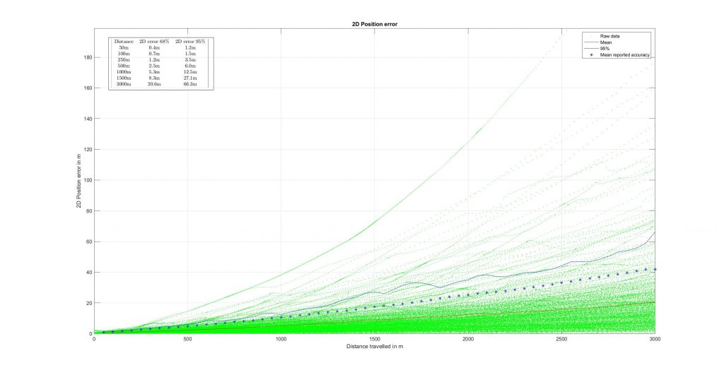
Before testing against a truth system in real tunnels, the road-test team created virtual tunnels by “unplugging” the GNSS receiver during open-sky conditions to simulate a GNSS outage forcing the system to navigate in dead-reckoning mode. This allowed a comparison between the performance of the inertial measurement unit (IMU) and a high-end truth setup. Logging the dead-reckoning results and readings from a high-end GNSS receiver used as a reference generated the data needed to emulate tunnels of different lengths on sampled portions of a given dataset. This enabled a creation of large enough set of test runs to be qualify performance in a way that is statistically significant.

Figure 3 shows the data from 1758 outages generated from 31 test runs. The results show that the positioning error is in dead-reckoning mode. On average, the horizontal positioning error grows by about 20 meters per kilometer, or approximately 2% over the distance traveled. The performance of the IMU strongly affects the tunnel test results, so it’s worth noting that this test setup used an ordinary IMU with average performance and not a high-end device.
Lane-accurate positioning
Other tests were performed in scenarios of varying complexity to verify that the combination of technologies can provide reliable lane-accurate positioning. Because of the stochastic nature of GNSS and IMU errors, individual test runs can either over- or underperform compared to the results presented below.
The least challenging test case, comprising highway driving in mostly open-sky conditions, showed that the solution is capable of 100 percent availability and is accurate to within 5.8 centimeters 50 percent of the time. The horizontal velocity component was accurate to 0.02 km/h 68 percent of the time.
During the tests, the system was able to achieve the most accurate RTK positioning – namely Fixed RTK, where enough satellites are visible to resolve all carrier-phase ambiguities to an integer number of wavelengths resulting in the highest possible accuracy – for 82 percent of the time. The system relied on RTK Float results, when insufficient satellites are visible to fully resolve the ambiguities (resulting in reduced accuracy), for 14.8 percent, and used dead reckoning for 3.1 percent. The overall accuracy was found to be ten times better than existing single-band receiver technology.
Road testing in the center of Paris, including urban areas and highways, demonstrated significantly superior performance compared to single-band, non-RTK receivers. In the worst-case urban canyon scenario, encountered in the La Défense district, performance exceeded the minimum requirements for V2X applications. Even though the number of visible satellites was insufficient to allow full ambiguity resolution, CEP68[i] was about 1.1 meters and the accuracy was at least 1.70 meters for 95 percent of the time (Table 2).
Finally, testing in a two-kilometer tunnel in Gothenburg, Sweden, showed the system to perform better than simulations had suggested. Drift was only 1 percent of distance traveled and the system converged to lane-level accuracy within two seconds due to factors including multi-frequency GNSS receivers, GNSS correction services, and a relatively accurate estimate of the position inferred from dead reckoning. While it is understood that lane-accurate positioning cannot be maintained in long tunnels, highly automated and driverless vehicles can use alternative positioning technologies to restore accuracy.
| Scenario | Open Sky (highway drive in Burgundy) | Urban (Districts 12-16, Paris) | Urban canyon (La Defense, Paris) |
| CEP50 in meters | 0.05 | 0.65 | 0.81 |
| CEP68 in meters | 0.07 | 0.85 | 1.11 |
| CEP95 in meters | 0.13 | 1.83 | 1.70 |
Conclusion: on the road to greater safety, comfort, and efficiency
With the combination of technologies discussed in this article — multi-band, multi-constellation GNSS receivers with built-in RTK algorithms, broadcast GNSS correction data, an IMU for dead reckoning, an external wheel-tick sensor, and a dynamic vehicle model — it is possible to create a positioning solution that provides continuous lane-accurate positioning, even in the most challenging environments.
Road testing has shown accuracy to be ten times better than existing technology. Continuous service can be maintained in urban environments through a combination of multi-band, multi-constellation GNSS receivers capable of maximizing satellite visibility in partly obstructed scenarios, dead reckoning to bridge short gaps in GNSS reception, and GNSS correction services for fast reconvergence after short signal interruptions. Moreover, system performance can be further enhanced by introducing information from other vehicle sensors such as cameras and radars, such that GNSS technology augmented with dead reckoning is ready for advanced automotive applications that can contribute to greater safety, comfort, and efficiency.
About the Author
Alex Ngi
Product Manager, Product Strategy for Dead Reckoning, Product Center
Positioning, u-blox
Alex Ngi is Product Manager for the ZED-F9K ADR module series and a member of the Product Strategy Team of the Product Center Positioning at u-blox. Prior to joining u-blox, Alex was Product Manager for Communications. Devices at Landis + Gyr, where he managed a portfolio of modules used in Industrial, Commercial and Grid metering segment sold internationally. The modules were the basis for Advanced Metering Infrastructure. He started his career as Field Applications Engineer for LSI Logic and held a product management position at multiple start-ups. Alex holds a BaSc in Electrical Engineering from the University of Waterloo, Canada.
Published in Telematics Wire


